
FLORIDA EAST COAST MARINE WEATHER (edited by Dean)
A weak cold front stalled across the FL/GA line Thursday. High pressure building over the western Atlantic off the east coast will bridge the dead front and unite with a weaker high to the south on Friday, strengthening the onshore flow over the weekend leading to cautionary conditions for near shore waters Saturday afternoon with possible small craft advisory conditions offshore as seas build Saturday evening and into early Sunday morning. The high pressure will then shift southward while gradually weakening late in the weekend, becoming anchored off the southeastern seaboard for much of next week. Consequently, winds and seas will gradually diminish from Sunday afternoon through the early part of the upcoming work week.
7-DAY SURF FORECAST
SATURDAY: Wind increasing from the east 14-21 mph and gusty with waves up during the day to 1.5-2′ (+pm) in close period (5-6 sec) east swell.
SUNDAY(28Apr): Onshore wind from the E/ESE “easing” some to 11-16 mph with waves leveling off at 1.5-occ 2.5′ (+/-0.5′) in close to moderate period (6-7 sec) east swell. Onshore wind may lay down a bit more by evening.
MONDAY: Wind lighter from the SE 7-13 mph with waves 1-2′ (+/-0.5′) in moderate period (7-8 sec) E/ESE swell.
TUESDAY: Wind light early, then S/SE 6-14 mph with waves 1-occ 2′ (+/-0.5′) in moderate to period (8 sec) ESE swell.
WEDNESDAY(May Day): Wind light S/SW in the morning, becoming SE 7-15 mph in the afternoon with waves 1-1.5′ (+/-0.5′) in moderate to longer period (8-9 sec) ESE swell.
THURSDAY:
FRIDAY:
7-10 DAY WEATHER OUTLOOK (with Hurricane Season Outlook)
Surf temps north of the Cape finally climbed out of the upper 60’sF in mid-April, exceeding the “magical” 70F-degree mark for good the following week. Given the longer daylight and lack of rainfall, SST’s will continue to climb through the mid-70’s In early May, possibly reaching the nitro tropical fuel 80F mark (several weeks early) throughout the SW Atlantic and Gomex around Memorial Day, so it would not suprise me to see Alberto form before the June 1 official start of the 2024 hurricane season. Modeling suggests several fairly strong lows will periodically spin up in the sub-tropical Atlantic well east of Hatteras, complimenting the ongoing onshore flow “trade wind” swell with an occassional longer period ground swell component… stay tuned!
CSU’s forecast for an active hurricane season was issued in early April: 2024 Tropical Forecast.
NWS Coastal Waters/Weather Forecast Links
St. Augustine to Flagler Beach
NWS Jacksonville Coastal Forecast
NOAA upgrading nearshore wave prediction.
7-day St. Augustine buoy sea height forecast (primary swell).
Florida Coastal Forecast Map (click on zone)
Marine Page for SE Georgia/NE Florida
_________________________________________________________________________________________
This graph illustrates the 14-day forecast for primary swell height and period for the St. Augustine offshore buoy:
St Augustine buoy 14-day forecast
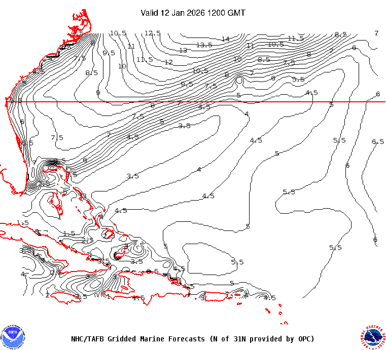
This map illustrates sea height contour (in feet) for the near shore Atlantic Ocean east of Florida:

 ______________________________________________________________________________________________________
Sea surface temps in the GOMEX and western Caribbean Sea.
Watch this GOES loop for lightning signatures that indicate intense convection.
______________________________________________________________________________________________________
The NHC Atlantic Tropical Weather Discussion and the tropical western Atlantic satellite loop are good tools to monitor the Atlantic basin for activity. Good links (updated regularly) to excellent private websites with forecast discussions monitoring tropical and non-tropical weather impacting Florida and the eastern US: Central Florida Hurricane Center and WeatherBELL
Here is a link to the impact hurricane activity has on our coast: Florida beaches face sand shortage
El Nino Southern Oscillation (ENSO) Discussion